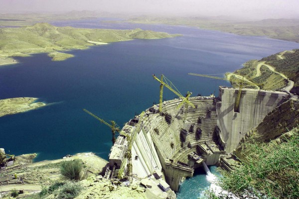

Salman Farsi (Ghir) Reservoir Dam:
1- Site Location
Salman Farsi (Ghir) Reservoir Dam is being constructed at Karzin Gorge on the
2- History of Investigations
The preliminary studies of the project (then called Mondosheshpir Project) were performed by Taleghani-Dafteri Consulting Engineers and the feasibility studies were accomplished by Mahab Ghodss Consulting Engineering Company from 1984 to 1990. Phase-II investigations began 1991 and were followed by the gradual commencement of construction activities including the diversion tunnel, upstream cofferdam, excavation of abutments, curtain grouting and the dam concreting after preparation of the drawings.
3- Main Objectives
- Supply 63 MCM of drinking water per annum to the cities in the project region
- Supply irrigation water in combination with groundwater resources to Ghir and Karzin, Aliabad, Afzar and Laghar Plains totaling about 33874 ha (including 15523 ha intended for expansion, 7332 ha considered for land improvement and 11019 ha decided to be maintained in the present conditions
- Generate hydroelectric energy by two turbine-generator units, each of 6.5 MW capacity with an annual output of about 50 GWh
- Flood control
- Reclamation of saline and alkaline plains that are apt to development
- Job creation and enhancement of agricultural crop and livestock production at the project region

4- Technical Features
A) Hydrology of the
|
Area of drainage basin |
13,050 km2 |
|
Annual average discharge |
16.3 m3/s |
|
Average annual inflow |
475 *106 m3 |
|
Average annual inflow (given Kavar Dam constructed) |
358* 106 m3 |
|
Average annual water regulation (given Kavar Dam constructed) |
297.7 *106 m3 |
|
10,000-year flood discharge |
15,882 m3/s |
|
Average annual precipitation |
250-300 mm |
B) Reservoir
|
Normal water level |
855.05 m.a.s.l. |
|
Water level during design flood |
859.85 m.a.s.l. |
|
Area at NWL |
4,850 ha |
|
Length |
19 km |
|
Width |
9 km |
|
Gross volume |
1400 *106 m3 |
|
Live volume |
1,236 *106 m3 |
|
50-year silt volume |
192 *106 m3 |
|
Regulation factor |
regulated vol./ Inflow volume = 0.85 |
C- Dam features
|
Type |
Arch concrete gravity dam |
|
Riverbed elevation under the dam |
758.05 m.a.s.l. |
|
Height from the deepest point of foundation |
125 m |
|
Crest length |
345 m |
|
Crest width |
7 m |
|
Width (maximum at foundation) |
63 m |
|
Concrete volume of dam body |
760,000 m3 |
D) Spillway
|
Type |
Gated chute spillway |
|
Spillway weir (crest) |
844.55 m.a.s.l. |
|
Number of bays |
8 |
|
Type of gates |
Radial |
|
Gate dimensions |
14 m (w) * 10.50 m (h) |
|
Discharge capacity |
15,882 m3/s |
E) Powerhouse
|
Capacity |
13 MW |
|
Number and type of turbines |
2 * 6.5 MW Francis |
|
Turbines axis elevation |
758.85 m.a.s.l. |
F) Temporary Diversion System
|
Type of upstream cofferdam |
Earthfill with clay core |
|
Height of upstream cofferdam |
23 m |
|
Crest length of upstream cofferdam |
530 m |
|
Diversion tunnel diameter |
12 m (with concrete lining) |
|
Diversion tunnel length |
285 m |
|
Type of downstream cofferdam |
Earthfill with cutoff wall |
|
Downstream cofferdam height |
9 m |
|
Crest length of downstream cofferdam |
150 m |
|
Discharge capacity (10-year flood) |
1,800 m3/s |
Consultant: Mahab Ghodss Consulting Engineering Company
Contractor: Peymab Company


